Oil Drilling - the Rocky Mountain Front and Blackfeet Indian Reservation
Wide open, roadless spaces, wildlife, and the people who depend on them and energy development along the Rocky Mountain Front: A Photo Record of “Progress.”
“Documenting current conditions on the Blackfeet Reservation and Rocky Mountain Front today is a very high priority. The landscape, Native American cultures, small towns,
sensitive and endangered wildlife and their habitat, are part of this complex puzzle and being altered at alarming rates.” - Tony Bynum 2010

Introduction, Setting and Scope The eastern front of the northern rocky mountains in Montana and southern Alberta occupies the interface where grizzly bears still freely move back and forth between the mountains and the prairie, is on the brink of massive change, particularly along Glacier National Parks east side. An interactive map of the current oil drilling on the Blackfeet Indian Reservation will help orient you. The eastern side of the crown of the continent ecosystem starts at the sharp jagged peaks in Glacier National Park, Waterton National Park in Alberta, CA, and the Rocky Mountain Front of Montana, where water flows to three oceans and literally divides the east and west. This area was known to the Blackfeet People as the Backbone of the World. More recently it has come to be included in a larger region known today as the Crown of the Continent ecosystem. The geographic region of concern stretches about 150 miles north to south, and 100 miles east to west. It includes the Waterton-Glacier International Peace Park, the Rocky Mountain Front, the Blackfeet Indian Reservation, and southern Alberta, Canada.
The focus now is on the Blackfeet Indian Reservation simply because that is where all the activity is now occurring. The Blackfeet Reservation maintains a rich, rare, and relatively intact system of short grass prairie, and associated wildlife, along with the steep jagged mountain ecosystem of the Rocky Mountains. In addition to the prairie-mountain landscape, the Blackfeet Indian Reservation supports a unique Native American and mixed non-Indian culture that is sure to see change as the demand for energy increases, and the oil boom progresses.
The driving force for change is the global, relentless demand for energy. In many ways, this force is impacting every system on earth, not only biophysical systems but social as well. In some real ways, the industrial oil complex holds the keys to the fate of the planet and its inhabitants. The “oil-boom” has reached this land. The industrial oil complex is already solidly established on the Blackfeet Indian Reservation and in the lands to the north in southern Alberta, Canada. The Waterton-Glacier International Peace Park shares a common border with the Blackfeet Reservation.
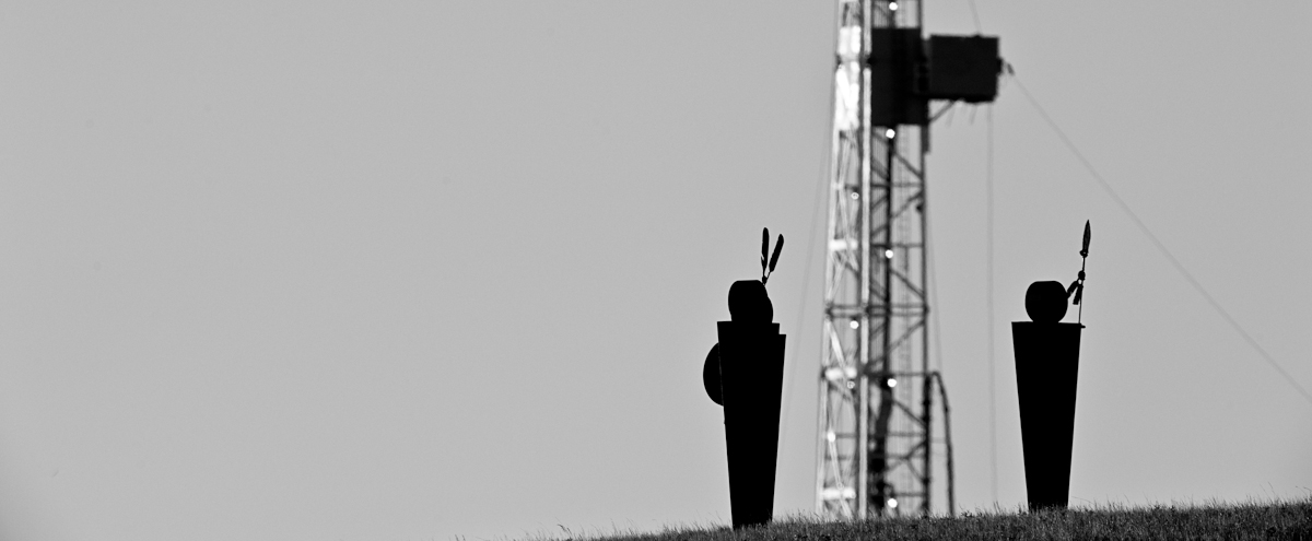
Oil and gas infrastructure development and wind turbines around the Blackfeet Reservation, and in southern Alberta, are expanding rapidly. Development of both resources is expected to increase markedly though the coming years. Full build-out is expected to be hundreds of new oil wells and pump-jacks, acres of wind turbines and associated infrastructure consisting of hundreds of miles of new roads, work camps, and support facilities which may including new hotels, and associated structures. Estimates are that 100-700 wells will be drilled over the next few years (12 wells are complete already with many more scheduled). Changes to this area will be unprecedented. It is not possible to know in advance exactly how the changes will play out in this setting. Still, there are enough other “oil boom” cases to safely assume they will be dramatic.

Importance of this project At this moment an opportunity exists to capture for educational and historical purposes, images of this mostly healthy, open and “intact” place. Today, we can still document the rapid transition of this cold, short grass prairie. There are progressively fewer such opportunities anywhere in the world. Such an opportunity not only is rare, it is perishable. All too commonly, journalists are in the position of creating the story after the fact, when the “good stuff is gone.” Here there is a rare opportunity to capture images of important landscapes and people before impacts occur. In this area, we still have a relatively intact mountain/prairie interface ecosystem that is home to grizzly and black bears, bull trout, Canada lynx, elk, deer, bighorn sheep, mountain goats and other elements all destined to change.

I want to emphasize that documenting current conditions on the Blackfeet Reservation and along the rocky mountain front today is a very high priority. Native American cultures, small towns, sensitive and endangered wildlife, open and un-tattered ecosystems are part of this complex puzzle and being altered at alarming rates.
The Local Aspect Small, rural communities in remote areas experience firsthand the most direct effects of commercial energy development. The Blackfeet have been on this particular landscape for at least 12,000 years. It now is a remote, mostly intact, relatively peaceful, Native American Reservation. It is the Blackfeet Nation. Now, that Nation appears to face a major energy boom and likely bust as the area changes to become an industrialized tapestry of roads, pump-jacks, evaporation ponds, cars, trucks, houses, stores and whatever else goes with it. At a minimum, it seems certain that once the fields are fully built-out, not only will the land not look the same, it’s people will never again behave the same. This project will document and share images of this landscape and its people before, during, and after the build-out of an intensive, high-cost, industrial energy system comprised of wind turbines, drill and “fracking rigs,” new roads and facilities, along with other associated activities and change. Already, some images of current conditions have been produced in anticipation of this larger project. They form the beginning of a vital baseline that must be established before the land and the people are dis-aggregated, the roads are constructed and the land, water, and wild grizzly bears become scarcer or worse, memories.
 The anticipated time frame for my project is 2010-2020. Filming is already underway with about two years completed. The first images are of a relatively intact landscape followed by photos of “progress.” Drilling, drillers, the local economy and the social impacts over the lifetime of the project will follow. The photographs will be used now to help educate people about this threatened region. At the same time, the project will build a digital archive for future generations who can better understand what the land looked like before and during the period of disturbance. Both digital and print images will be created and widely shared with organizations and the public though online media, social networks, web blogs, and personal presentations. Once the road’s are in, the well pads created, the drill rigs erected, ponds dug, the power lines strung and the turbines begin churning, the current largely unobstructed landscape will be a memory. Memories are all that is left when you no longer can see something in person. Images sharpen and stimulate memories. Images are likely to persist through longer spans of time and are more dependable than memories.
To document the entire build out over the coming years I plan to photograph the story from both the land and the air, and with both stills and video. I will follow and record a few specific people as well. I'll shoot and post/publish regularly in order to generate and maintain interest. The campaign will be driven both online and in person. As is so effective today, social media: for examples, Twitter, Facebook, Linkedin, will be an important vehicles. I will employ my personal network along with the much larger network of the people and conservation organizations who care about this place and project - basically everyone who pays attention to natural ecosystems, and likes cowboys, Indians, wildlife, and glaciers.
Cost of this project for year one and two is estimated to be $40,000. The costs include expenses for local travel, fixed wing airplane rental, assistance in the field and office when necessary (mainly web design and development, and continued costs for hosting and management), some special equipment including a ground based radio controlled aerial platform. The aerial platform will enable me to capture low level aerials that offer a better perspective of the relationship between the development and the landscape. It will also be more cost effective, and I can react to local weather conditions and shoot aerials without always the need for a fixed wing aircraft. The remainder will pay for time to capture, process, market and produce the project.
About Me Education, Science and Business Tony lives in East Glacier Park, MT on the Blackfeet Indian Reservation with his 9 year old daughter. He has more than 20 years of professional and executive environmental management experience. He holds a Master's of Science in Resources Management degree, an undergraduate degree in Geography and Land Studies, and a minor in Environmental Studies from Central Washington University. Tony has managed more than 30 complex scientific research projects for the Environmental Protection Agency from coast to coast, he’s worked in the private sector and for Indian Tribes and non-profits. Over his 20 year professional science career he has participated in the development of countless environmental policies and/or regulations from the EPA, to the USFS, BLM, DoD, DOE, BOR, Washington State’s DOE Wetlands mitigation banking regulations, air and water quality plans, and more. Tony’s a board member of the professional outdoor media association, the East Glacier Park School Board, and a current member and former officer on the East Glacier Park Volunteer Fire Department and a principal member of the Glacier Two Medicine Alliance.
Tony owns Tony Bynum Photography & Glacier Impressions Gallery. In 2004 Interior Secretary Gail Norton appointed Tony to the Montana Resources Advisory Council (federal advisory committee, member 2 years, chairman 1). During that time, from 2005 until early 2010 he also managed complex scientific research projects at Portage, a private consulting firm. From 1999 to 2001 he was a special assistant and the acting Senior Indian Program Manager at EPA in Washington, D.C., responsible for a $2 Million budget, implementing federal statutes, strategic planning, GPRA reporting, and federal rule making. In 1997 and 98 he was the co-chair of the technical oversight committee of the Western Regional Air Partnership.
Bynum’s images have appeared on the covers and in copy of many of the countries major traditional outdoor recreation focused magazines, including Field & Stream, Outdoor Life, Sports Afield, Fair Chase, Texas Sporting Journal, Eastman’s Hunting, and Eastmans Bow hunting, Bugle, Bowhunt America, Montana Outdoors, Montana Magazine, Western Hunter, Western Horseman, and many more. Tony recently became the photo editor for Elk Hunter Magazine and In 2010 he was selected to produce commercial advertising images for the State Of Montana’s Office of Tourism. His images are currently display on buses, trains, billboards, windows, skylights, and elevator doors from Chicago to Seattle, WA.
His list of publication credits is extensive including other industry publications like, National Geographic, the NewYorker, The Food Network Magazine, Popular Photography, Digital Photographer (UK), Delta Sky, Empire Builder and many, many more (complete list between 2009-2011).
Tony’s often hired to produce unique, compelling, thoughtful images to compliment editorial writing in magazines and books. He has worked or traveled to all of the lower 48 states, Mexico, and much of Canada, and writes regularly for his blog. He’s active on Twitter, Facebook, Linkedin, Behance, and moderates and edits photography, outdoor activities and hunting forums on several very popular websites.
Current Interests and Positions 1. conservation photography and the Rocky Mountain Front 2. board member of the Professional Outdoor Media Association 3. board member of the East Glacier Park School District 4. member and past training officer on the East Glacier Park Volunteer Fire Department 5. principal member of the Glacier Two-Medicine Alliance. 6. Author of the blog, www.glacierparkphotographer.com 7. regularly consults with the TWS, the Montana Wilderness Associating, the Montana Wildlife Association, the Coalition to Protect the Rocky Mountain Front, and many other state and national conservation and resource management organizations/groups.
Personal Commitment Central to Tony’s lifestyle is giving something back. As a young man he decided that giving was an essential part of his core belief. To him, giving is a lifestyle choice; it’s more than a duty. There are few things more rewarding or more valuable than offering yourself up to help others. If his entire life were mapped topographically, the ridges would represent the edges of his experience, while the blue line in the valley bottom would signify his giving; it’s central to his life and like the river at the bottom of the valley, all things run though it.
Tony has a unique, and truly authentic set of real-time, current and tested skills in business, management, governance, science, writing, communications, technology, social leadership and teaching. He’s a trained facilitator and has served on three boards where consensus was the agreed processes for decision making. He’s an educator, a leader by nature, a father, and a great friend.

"In the end we will conserve only what we love. We love only what we understand."
- Baba Dioum
A Blackfeet Oil Drilling Press Kit containing project information and photographs to accompany your story is available.